GDYNIA TOWN COUNCIL
81-963 Gdynia, ul. Piłsudskiego 52/54
tel.: (058) 6207271, fax: 6208226
Chief of local authority
President WOJCIECH SZCZUREK
Controlling maritime authority
GDYNIA HARBOUR
MASTER'S OFFICE
ul. Polska 2
81-339 Gdynia
Contact of maritime authority
Gdynia Harbour Master
Wojciech Oziemski
tel.: (058) 6202853, fax: 6200591
Harbour radio
VHF Channel 16
Navigational aids:
The coast S of Gdynia is steep and, in places, cliffy. Cypel Redłowski
(54°29'N, 18°34'E) is steep and continually erode by wave action.
Between this high land and Orłowo, 0.75 mile E, a valley runs inland.
The wooded coast is formed of steep cliffs and is bordered by rocks.
The long building of the bathing establishment on the Beach near
Orłowo is easily identified.
Quayage and berthing facilities
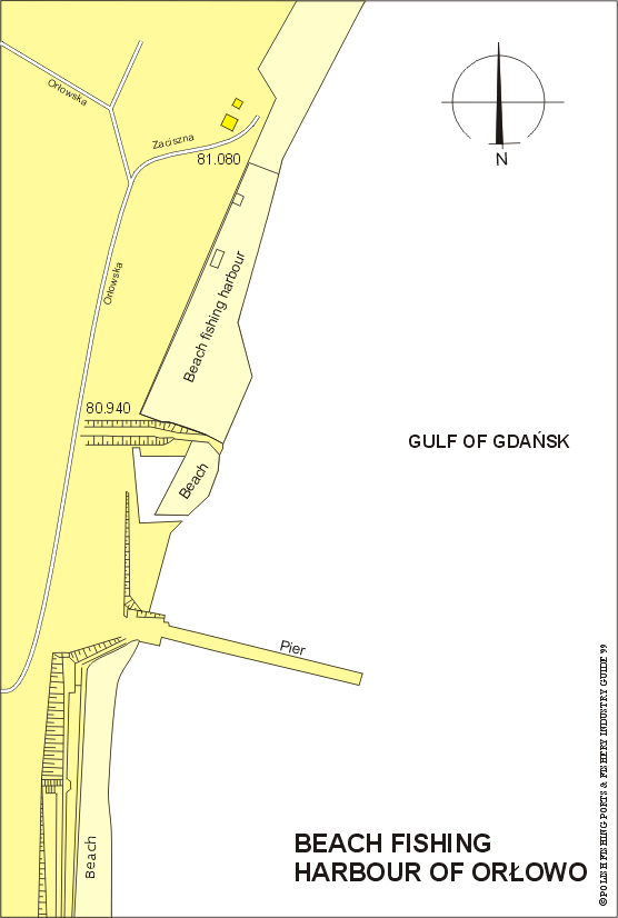
A pier extends about 180m from the shore at Orłowo. A fishing harbour
is on open beach 140 m long, from which boats are launched and
retrieved with an electrical winch.
General facilities
Fuel
Available at Gdynia harbour.
Water
Available locally.
Slipping
Available at Gdynia harbour.
Stevedoring
Available at Gdynia.
Fisheries facilities
Ice
Available at fishing harbour of Gdynia.
Cold storage capacity
Available at Gdynia.
Chilling storage capacity
Available at Gdynia.
Frozen fish transport
Available at Gdynia.
Types and size of fishing fleet
6 fishing boats (length of 5 to 7m) and average engine power of 25HP
Types of fish landed (in tonnes) (1995)
Flounder
28.8
Cod
15.3
Herring
5.7
Eel
3.0
Pike-perch
1.3
Eel-pout
0.5
Garfish
0.4
Salmon-trout
0.1
Others
1.0
Total
56.1
Nearest airport:
Rębiechowo, approx. 22km
General information:
The fishing harbour was established in Orłowo in the 19th century.
In 1829 fishermen Johann Adler established an inn at the mouth of
small river Kacza, which was the first landmark at the settlers.
In 1921 there lived seven fishermen families in Orłowo, and they
used one sail fishing boat and thirteen row boats.
Orłowo is a S district of Gdynia situated at the foot of a steep
cape-over 90 m high. About 3 cables northward of Orłowo is a
picturesque elevation known as Redłowska Islet, which stretches
over several km and ends abruptly in a steep slope in the centre
of Gdynia.
In 1935 Orłowo was included in Gdynia as its district. Its shore
descend steeply into the sea and its woods of mixed trees, with
specimens of rare Swedish sorb-tree, are under special protection.
There is a hill, known as Stone Hill, which is a splendid vantage
point from where the town and harbour of Gdynia may be seen.
At Orłowo there is a pier built in 1934 that extends about 180m
from the shore, which is used by visitors to go out for a walk.
Salmon nets are laid annually from mid January to mid May, in the
area between the Gdynia inner anchorage and Orłowo, within 2 miles
of the coast. In order to avoid damage to the nets during that period,
vessels should keep clear of the area.