|
|
| Polish Ports - KATY RYBACKIE |
| Local commune administration authority |
|
SZTUTOWO COMMUNE COUNCIL
82-110 Sztutowo, ul. Gdańska 55
tel.: (055) 2478324
|
Chief of local authority
Commune administrator
EUGENIUSZ WYRZYKOWSKI |
| Controlling maritime authority |
|
|
KĄTY RYBACKIE
BOATSWAIN'S OFFICE
82-104 Kąty Rybackie
|
Contact of maritime authority
Harbour Boatsman
Klemens Grucza
tel. (058) 2478719 |
Harbour radio
VHF Channel 16 |
Navigational aids:
From Mikoszewo, the coast curves E and finally NE for about 39 miles.
For the greater part it consists of a narrow strip of land known as
Vistula Spit, which forms the NW side of Vistula Lagoon. The land is
fringed by a sandy beach, rises to heights of between 15 and 30m,
wooded in places. Kąty Rybackie lies about 3.5 miles NW of Gdańsk
Light beacon, at the root of Vistula Spit. Kąty Rybackie has an
access to the Gulf of Gdańsk from N side and to the Vistula Lagoon
from S side. On the Vistula Lagoon there is Kąty Rybackie
Light-buoy black and white stripes, cross top mark) moored
1.5 miles ESE of harbour entrance. |
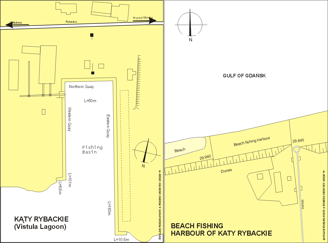
Quayage and berthing facilities
From the side of Gulf of Gdańsk there is beach harbour for Baltic
fishing boats. From the side of Vistula Lagoon there is the basin
for Lagoon fishing boats. The east quay of the basin is 160m long,
the west quay is 101m long and the north quay is 50m long. There
are depths of between 1.5 to 2.0m along the quayage. |
| Fuel |
Available. |
| Water |
Available on quayside. |
| Slipping |
machinery repairs can be carried out. |
| Stevedoring |
Not available. |
| Ice |
Production plant, capacity 10t per day. |
| Cold storage capacity |
Not available. |
| Chilling storage capacity |
Chilling room for 25t of fish. |
| Frozen fish transport |
t available locally. |
Types and size of fishing fleet
13 fishing boats (length of 5 to 7m) and average engine
power of 25 HP from the Gulf of Gdańsk side and 57 fishing boats,
mainly wooden, average length of 6.7m and engine power
of 29 to 52 HP from the side of Vistula Lagoon. |
| Types of fish landed (in tonnes) (1995) |
| GULF OF GDAŃSK: |
| Flounder |
74.0 |
| Herring |
32.5 |
| Pike-perch |
2.1 |
| Turbot |
1.2 |
| Salmon-trout |
1.1 |
| Roach |
0.1 |
| Eel |
0.1 |
| Bream |
0.1 |
| Others |
0.1 |
| Total |
111.3 |
|
| VISTULA LAGOON: |
| Herring |
95.5 |
| Roach |
27.5 |
| Perch |
11.2 |
| Eel |
6.8 |
| Pike-perch |
6.2 |
| White bream |
0.3 |
| Lamprey |
0.1 |
| Others |
0.4 |
| Total |
148.0 |
|
Nearest airport:
Rębiechowo, approx. 55km |
General information:
Kąty Rybackie is a village with a small fishing harbour, about
3.5 miles north-west of Gdańsk Light-beacon, in which there are
depths of between 1 and 1.5m. In 1680 a wealthy English merchant
William Ramsey of Buckingham put up a mansion - house here. In 1780,
an inn was built. Originally Kąty Rybackie was part of Sztutowo
and from 1808 became an independent commune. Now the village is
a seaside resort and holiday makers visit a nice sandy beach 2km
long. There are two fishing harbours at Kąty Rybackie. The beach
harbour, 100 m long is from the side of Gulf of Gdańsk. The east
side of the beach harbour is connected by road with the village.
A small fishing port with quayage is situated from the side of
Vistula Lagoon. There is a slip for fishing boats and small hull
and machinery repairs can be carried out. The boats from the
beach harbour have been transported by lorry to the port of
the side of Vistula Lagoon, for fishing during the season.
The total catch of freshwater fishes in the Vistula Lagoon
(area of the Polish part of the Lagoon 328 km2, the mean
depth 4m), equalled 320t (1955). The bulk of the catch was eel,
roach, bream, pikeperch and perch. Fishing was performed by
around 250 fishermen, whose main fishing gear were fyke-nets
and gill-nets. The most exploited fishing grounds were situated in
the eastern area of the Vistula Lagoon. Kąty Rybackie services
tourist traffic. 2,111 passengers took trips on board ships of
the "white fleet" in 1996. It should be stressed that ship traffic
in the Vistula Lagoon is seasonal. The season of passenger ship
traffic lasts from May 1st to October 5th, every year. |
|