|
| ||||||||||
|
|
Useful addresses and telephone numbers Country code: +48
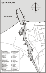
Introduction to Ustka Ustka is a fishing and commercial port situated along widened and expanded part of Słupia river, 18 km from the town of Słupsk. The population is 7,468. The port and town are located at the mouth of Słupia river. Fishermen lived there as early as the 12th century. It was a harbour of the Slav Tribes of Pomerania, where numerous cargoladen ships called. The origin of port is dated from the 14th century during the reign of West Pomeranian Princes. By the 17th century the port has been developed considerably. At that time Ustka served the goods to and from Słupsk - the largest town located on the Słupia river. Through the 17th - 19th century the importance of Ustka and Słupsk decreased. The Thirty-Year War had a great has influence on the crisis. There was almost no shipping traffic in the port. Only 20-40 ships by year entered Ustka. They delivered salt, wine, iron, herrings and exported shipbuilding and architectural wood also firewood. The begin of 20th century saw a rapid growth in Ustka. The port has mostly serviced sailing vessel cabotaged Baltic trade. Ustka is known as a seaside and a natural therapy resort. There are medical mud, sulphur and other mineral baths. At present, the town city has preserved many examples of 19th century domestic architecture, including elegant villas constructed of bricks, guest houses and hotels open for tourist throughout the year. Navigation information
The entrance is formed by two almost parallel concrete moles of 303 m and 420 m lengths. It is 40 m in width and has a max. depth of 6.0 m. The main fairway to the inner port is 28 m wide. The limiting dimensions for vessels entering the port are: length 58 m, width of 11.5 m and draught of 4.5 m. The current sets W across the entrance with winds from the N, through the E to the SSE, and E with winds from the N, through the W to the SSW. A wind rate of 2.0 knots is normal when blowing parallel to the coast. With winds from the SSW and the SSE, the current flowing out of the river is noticeable, which may reach a rate of 4.0 knots during the spring thaw. With heavy gales from the WNW, through the N to the ENE, water levels may rise to 1.0 m above the mean level. With gales from the ESE to the WSW, through the S, levels may fall a similar amount, but such variations are unusual. Pilotage is compulsory for all vessels of over 40 m LOA and for vessels carrying dangerous cargoes. Vessels should send ETA and request for pilots 24 h before arrival at the roads. Pilot boards 1 Nm NW of the harbour entrance. For the radiotelephony connections should be used VHF Channel 12 and 16. Cargo traffic in statistics The total throughputs of the Port of Ustka amounted:
Port facilities The harbour consists of an avanport and an inner port. In the inner port there are four basins with 11 concrete quays of total length 3,400 m. Some of them are connected to the general railway system. There are grain elevators on the eastern bank of the river.
Charges Harbour charges are defined in town council of Ustka resolution (Uchwała Nr XXXII/260/2005 Rady Miejskiej w Ustce z dnia 28 kwietnia 2005r.). The tonnage charges are regulated by the Director of Maritime Office in Słupsk (Zarzšdzenie wewnętrzne nr 21 Dyrektora Urzędu Morskiego w Słupsku z dnia 22 grudnia 2004r.). Pilotage The charges for pilotage services are quoted according to the Pilot's tariff for Pilotage Services in the Port of Kołobrzeg and Ustka. The following charges refer to pilotage from/to an anchorage of the Port of Kołobrzeg.
|
||||||||||||||||||||||||||||||||||||||||||||||||||||||||||||||||||||||||||
|
||||||||||||||||||||||||||||||||||||||||||||||||||||||||||||||||||||||||||
| adresy instytucji morskichpraca na statkach Stocznie - Remontyszukaj firmy morskiej: KWIDZYN | ||||||||||||||||||||||||||||||||||||||||||||||||||||||||||||||||||||||||||


