TRZEBIATÓW TOWN AND COMMUNE COUNCIL
72-320 Trzebiatów, Rynek 1
tel.: (0931) 72984, fax: 72619
Chief of local authority
Mayor DOROTA KLIMOWICZ
Controlling maritime authority
MRZEŻYNO BOATSWAIN'S OFFICE
ul. Marynarska 1
72-330 Mrzeżyno
Contact of maritime authority
Harbour Boatswain
Antoni Musielewicz
tel.: (0931) 66119
Harbour radio
VHF Channel 16
Navigational aids:
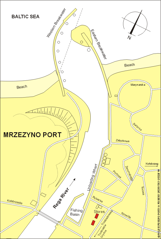
The mouth of Rega River is protected by two breakwaters leaving an
entrance 30m wide. The eastern breakwater, which is the longer,
extends 300m from the shore. Difficult conditions for navigation
on the entry from NE make the harbour useless for barge service and
as a shield for other vessels. The fairway (2.5m deep) is often
silted up.
Quayage and berthing facilities
The river is suitable for coastal fishing vessels and there are landing
places on each breakwater. Depths in the harbour entrance and near the
langing places are variable and the harbour is not fully used because
of the moving sediments and sand dumps which gather at the beds of
the breakwaters. There is unloading wharf of 154 meters long and
together with the fishing quays total length of quays is 520 meters.
General facilities
Fuel
Available in Dziwnów or Kołobrzeg
Water
Available
Slipping
Slip for fishing boats
Stevedoring
Not available
Fisheries facilities
Ice
Not available locally. Available in Dziwnów or Kołobrzeg
Cold storage capacity
Available in Świnoujście or Kołobrzeg
Chilling storage capacity
Not available
Frozen fish transport
Not available
Types and size of fishing fleet
Only 6 fishing boats (length of 9 to 10m) and average engine power of 50 HP.
Types of fish landed (in tonnes) (1995)
Cod
22.4
Herring
20.1
Flounder
18.3
Pike-perch
6.4
Salmon-trout
5.3
Roach
5.0
Eel
1.5
Total
232.6
Nearest airport:
Goleniów, approx. 60km
General information:
Mrzeżyno is both a fishing village and summer resort. Situated on
the east bank, near the mouth of Rega River. The first written record
about this fishing settlement was dated 1250. In 1787 fishing was
carried on, by, 24, fishermen. From 1840 Mrzeżyno is known as a summer
resort. Mrzeżyno has one of the nicest bathing beachs on the Polish
shore of the Baltic Sea. Located on an artificial excavation of Rega
River near marshes and boggland. The village has old fisherman houses
from the 18th century. There is a yacht harbour. Fishing quays are
179 meters long with depths of 2.0m to 2.5m. Permanent population
is about 600 but during summer seaside season a lot of tourists come here.